Winter Wonderland, North Georgia Style

IMG_2086

Top of Georgia Hostel, Hiawassee, GA, Friday February 27, 2015 — A couple of days ago I marched into the woods to begin my duties helping hikers get through their first of the Appalachian Trail’s (AT) 14 states.

My duties are to educate hikers on Leave No Trace principles, which at its essence means that they are supposed to live in and leave the wilderness undisturbed by their presence.  “Leave only footprints” is the mantra.

We also hike out trash we find, help where we can and be a friendly presence on the trail as well as eyes and ears.

The first day began at 9 a.m. at about 70 miles north of the AT’s start point on Springer Mountain.  This section begins with a 1,500 foot climb right out of the door.  It took about a nano second for me to fully appreciate that the 2,200 mile-strong “trail legs” earned on my thru hike last year were past their expiration date.  Ooooph!

But I slushed on through the snow, stopping every 50 yards or so to cool down and catch my breath.  I’m packing about 35 lbs. of cold weather gear, gaiters, food, stove, first aid kit, water purification pills, tooth paste and the like.  Then there’s my trail saw, trash bags and bungee chords.  Oof Da, as the Norwegians say.

First stop was to check the Deep Gap shelter and pick up some detritus left behind by hikers.  Not much thank heaven.  Then to push on to the Tray Gap shelter, about seven more miles up hill and ahead.

A storm was expected to roll in about 5 p.m., so no day dreaming was allowed.

IMG_2051

The snow was typically heavy and wet southern snow ranging from four to eight inches deep with some drifting to a foot.  My calves were screaming from pushing up hill and slipping back.  What would have been a five hour hike on dry trail unfolded in just nine hours.

Of course the storm hit around four o’clock, an hour early.  I arrived at the shelter covered in thick white stuff.  Three hikers were there.  They were strong and competent though the strongest among them told me that he’d been plowing Georgia snow for 12 days!  That’s normally five to six days for most people just starting out.

I ate and took a deep dive into my down bag and reached slumber depth before anyone could say it’s snowing.

Throughout the night the wind whipped snow across my face, waking me occasionally.  Who knew what we’d find in the morning.

IMG_2060

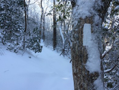
The dawn sparkled with a fresh landscape of new snow, six to 12 inches adrift over everything.  At least it looks good, I reasoned.

IMG_2064 IMG_2065

Now this has always been a family blog.  But hikers have to do their business in the morning.  Let’s just say that some mornings are easier than others.

IMG_2068IMG_2088

The snowscape was inspiring.

IMG_2052

Along the way I removed trail obstructions and noted some heavier work for later.

IMG_2054IMG_2055

Wild pigs love to root and pillage.

Needless to say, the slogging was tiring.  The smart decision was to push on another 8 miles and over another 1,500 foot climb to Unicoi Gap where I could get a ride back to the Top of Georgia Hostel where I’ve set up my base camp.  I’d totaled only 20 miles.

IMG_2098

Today is a zero day and the snow is melting.  Tomorrow it’s back to Unicoi and another steep climb up Blue Mountain.  We’ll see how far I get.
Back to the future

IMG_1327

February 14, 2015 — I’m packing up and headed for some training in the Great Smoky Mountains National Park.  The Appalachian Trail Conservancy (ATC) has a base camp there used for training year round and for trail crews in the summer.

I’ll be joining a group of ridgerunners.  Ridgerunners patrol in season the Appalachian Trail (AT) from beginning to end.  The onset of thru hiking season is just around the corner,  and it’s time to get ready.

My role is to test the use of volunteers to augment the paid seasonal staff.  The difference is that I’ll be there only for the month of March.  Everyone else is there for the duration of hiking season – until autumn.

The need for the test is that AT (and other trails) is expected to see a large increase next year in thru hike attempts in response to the movies “Wild” in theaters now, and “A Walk in the Woods” which will be in theaters before summer’s end.

ATHikers

Historical data establishes a direct correlation between increases in thru hike attempts and popular mass media about hiking or the AT.  Books, television, videos have done it every time.  Now we have Hollywood to help drive up the numbers next year.

My patrol area is the AT’s 78 miles in Georgia.  We walk five days and spend four nights on the trail.  The sixth day is off.  Of interest, we hike southbound (SOBO) for the purpose of meeting as many thru hikers as possible.  Once we reach Springer Mountain, the Georgia Appalachian Trail Club shuttles us back north to do it all again.

Among our duties is to help hikers as we can, educate them on Leave No Trace™ principles and trail etiquette, pick up litter, do minor trail repairs, and report issues we cannot handle.  These hikes are not about miles.  They’re about the smiles.

The forecast isn’t friendly, at least for next week.  It’s going to be colder than a well digger’s backside in the Smoky’s.  So much so that we’ve been told that we’ll be spending our nights at the basecamp and none sleeping outside. Yea!  No sense practicing being miserable.

The weather in Georgia will probably whip back and forth between ugly and nice with huge improvements toward the end of March.  Still, the southern Appalachians are high enough that snow can fall into April, even when the temperatures in Atlanta and points south are cooking.

IMG_1236IMG_1196

I’m looking forward to some former stomping grounds.  Dick’s Creek Gap is just short of the North Carolina border and the northern edge of the patrol area.  Blood Mountain is in the center of the sector.  It’s got some interesting native American history with some ornery bear activity on the side.

I plan to blog daily, but publish them as every fifth or sixth day as time permits just like I did on my thru hike.  So stay tuned.  If anyone has read Bill Bryson’s “A Walk in the Woods, you know this could be interesting.

Went for a walk on a winter’s day

IMG_1976_2

Compton Peak

Appalachian Trail, Shenandoah National Park (SNP), Compton Peak to Jenkins Gap, Saturday February 7, 2015 —  Each inch of the Appalachian Trail has a human who is responsible for its upkeep.  These folks are called overseers.  Stewards would be more like it.

Overseers remove blown down trees, branches, clean and repair erosion control structures like check dams and waterbars, build new ones as needed, cut back vegetation that may harbor ticks and pick up trash when necessary.

As luck would have it, yours truly is about to become responsible for one mile of the Appalachian Trail from Jenkins Gap to the top of Compton Peak (SNP north district).  That’s AT northbound miles 957.4 to 958.7.  I’m about to become a proud papa.

This is a handsome section of trail if I do say so myself.  From the Jenkins Gap parking lot, it’s optically flat for about a half mile.  This part has been burned over in the past. I’m going to have to learn more about the fire.  Consequently it is infested with lots of vines and thorns. These will require a lot of attention.

The second half begins with a nice flight of stone steps leading to a sluice a bunch of us built two years ago.  The Sluice keeps water from a healthy spring from washing out the trail.  The grade to the top is gentle by any standard.  The treadway throughout has a minimal number of rocks.  Yea!  This isn’t Pennsylvania, you know.

IMG_2002

The trail section ends on top of Compton peak.

A blue blaze trail crosses the AT on Compton Peak leading west to a nice overlook and east to a columnar basalt formation which is one of the few on the east coast.  Eighteen months ago we built 68 stone steps to help make the trail to the basalt formation more passable and to help control erosion.  Judging from the tracks in the snow, it’s popular year round.

IMG_1999IMG_1998

The primary reason for building the steps to the basalt formation was a spring that washed out the trail.  Looks like we’ve got more to learn about water management.

IMG_1995

Columnar basalt.

The day was pleasant.  The temps hovered around 32F with zero wind.  The sun was mostly cloaked by heavy lead-colored clouds.

Without overseers, trails would quickly become impassible no matter whether they are in a state or local parks or one of the big ones in the national trail system.

IMG_1979IMG_1980_2

Before and after.

IMG_1991 IMG_1992

In total there were a even dozen obstructions that had to be removed.

IMG_1985_2

Jenkins Gap.  End of the line.